
 Omo Valley Tribes
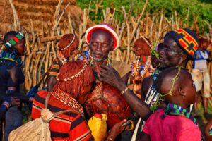
Experience another way of life as you’re welcomed by some of the 88 cultural communities of the Omo Valley. Famed for its cultural traditions and tribal diversity, this remote corner of Ethiopia has been a cultural crossroads for millennia.
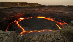
Erta Ale (meaning ‘Smoking Mountain’ in the Afar language) is Ethiopia’s most active volcano and contains one of just six active lava lakes on Earth. Sitting in the Danakil Depression under 40°C (104°F) heat, it’s as unforgiving as it is visually staggering.
Liquid lava pierces the charcoal crust of Erta Ale.
 Dallol
Characterized by bright, multi-coloured springs, fissures, and geysers, and with average annual temperatures of 35°C (95°F), Dallol is one of the most visually compelling and geologically fascinating destinations on Earth.
Bubbling Supersatured Springs at Dallol.
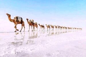
Salt Lakes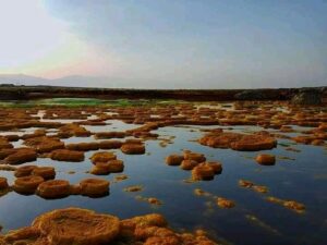
Lake Karum (aka Lake Asale) and Lake Afrera (aka Lake Afdera) are the two hypersaline lakes in the Danakil Depression. Both are visited on most tours of the Danakil, with Lake Karum being one of the most visually striking lakes anywhere on Earth.
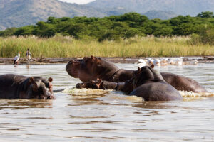
Lake Chamo
Lake Chamo is one of the Rift Valley’s most beautiful lakes. A popular stop on the way to or from the Omo Valley, Chamo is one of the best places to see crocs in Ethiopia.
 Attractions around the Lake
Spanning 30km from north to south and around 15km across, Lake Chamo is located just south of the Main Ethiopian Rift south of Addis Ababa.
The lake sits at an elevation of 1,110 meters, looking over the central rift valley. The nearest town is Arba Minch, the gateway town into the Omo Valley.
Lake Chamo is a popular trip in the morning or afternoon from your base at Arba Minch, typically before you head into the Omo for 4-5 days exploring the region.
Lake Chamo is most famous for its large hippo and croc populations.
Crocs of Lake Chamo
Home to four of the six largest crocodiles in the world, Lake Chamo is notorious for its crocodile population.
Towards the northern end of the lake, near the Nechisar National Park, many giant crocs can be found sunbathing on the banks or nestled within the reeds.
Living much deeper in the Nechsar National Park, Zebras are sometimes spotted at these waters, and the crocs will wait in the murky waters for them to take a drink…
Nominated in 2009 to the World Heritage Tentative List, Bale Mountains National Park (BMNP) is a national park in Ethiopia with one of the highest incidences of animal endemicity of any terrestrial habitat in the world. The Park encompasses an area of approximately 2,150 km2 and is divided into five distinct and unique habitats: the Northern Grasslands (Gaysay Valley), Northern Woodlands (Park Headquarters), Afro-alpine Meadows (Sanetti Plateau), Erica Moorlands, and the Harenna Forest. The park is known for being home to the largest populations of both the endemic and endangered Ethiopian wolf (Canis simensis) and mountain nyala (Tragelaphus buxtoni), as well as the endemic Bale monkey (Chlorocebus djamdjamensis) and giant mole rat (Tachyoryctes macrocephalus). The endangered painted hunting dog (Lycaon pictus) once existed in the park (with relict packs reported in the 1990s), but may now be extirpated due to human population pressures in this region.[1]
Location
The Bale Mountains National Park is located in southeastern Ethiopia, 400 km southeast of Addis Ababa and 150 km east of Shashamene in the Oromia Regional National State. It belongs to the Bale-Arsi massif, which forms the western section of the southeastern highlands. The boundary of the BMNP lies within five woredas: Adaba (west), Dinsho (north), Goba (northeast), Delo-Mena-Angetu and Harena-Buluk (southeast). The park area is encompassed within geographical coordinates of 6º29′ – 7º10’N and 39º28′ – 39º57’E. Geology and Glaciation
The Bale Mountains were formed prior to the formation of the Rift Valley from lava outpourings, which covered all underlying rock formations between 38 and seven million years ago. The rocks of the volcanic outpourings are pre-dominantly trachytes but also include rhyolites, basalts and associated agglomerates, and tuffs. The main Bale highlands consist of a vast lava plateau with at least six volcanic cones, each more than 4,200 meters high, which have been considerably flattened by repeated glaciations.
There have been at least two glacial periods in the history of the mountains and they were glaciated as little as 2,000 years ago. During the last ice age, the Bale Mountains were one of the most extensively glaciated areas in Ethiopia with a total area of ice in Bale of approximately 180 km2. There was a 30km2 ice cap around the peak of Tulu Dimtu (the second highest mountain in Ethiopia) on the Sanetti Plateau and individual glaciers of considerable thickness reached down to 3,200 meters. As a consequence, the landscape as we see it today is the lava outpourings much modified by over 20 million years of erosion by water, wind and ice.
There are certain geological features that remain an enigma to geologists and glaciologists such as the striations that appear on shallow hillsides on the Sanetti Plateau. Boulder grooves (large stone sorted stripes two to four meters wide and eighty meters long), till ridges and numerous glacial valleys, such as the Togona Valley on the northeast facing slopes of the Sanetti Plateau, provide evidence of the ice-age effects on the landscape of BMNP. Until the beginning of deglaciation (13,000 to 14,000 years ago) the snowline was at 3,700 meters and the upper tree limit in the Bale Mountains was well below 3,000 meters. Fluctuations in climate over the last historical period, including the last 3,000 years, have dramatically affected the vegetation and other biodiversity in the highlands.
Hydrology
The Bale Mountains play a vital role in climate control of the region by attracting large amounts of orographic rainfall, which has obvious implications for livestock and agricultural production. Some 600 – 1,000 mm fall annually in the lower altitude areas, while 1,000 – 1,400 mm fall in areas of higher altitude, and over 12 million people from Kenya, Somalia and Ethiopia are dependent on water from the Bale massif.
A total of 40 rivers rise in the BMNP area, contributing to five major rivers: the Web, Wabe Shebele, Welmel, Dumal and Ganale. Additionally, the Bale massif is the source for many springs in the lowlands, which are of paramount importance as they are the only source of water year-round. People living south of the National Park are completely dependent on good management of the water resources from the highland areas. If the flow of these rivers is altered in any way – through deforestation, overgrazing of pastures and/or over abstraction for irrigation (all of which are occurring at present) – a highland/lowland imbalance results with loss of perennial water in the lowlands. If such a situation arises, the dry season range of the people and their livestock reduces dramatically and they concentrate about whatever water source remains. It is widely recognized that such uneven distribution of people and livestock leads to rapid and lasting degradation. The people are, therefore, likely to become increasingly food-aid dependent if the water catchment areas of the Bale Mountains are insufficiently protected. There is already evidence that over abstraction of water in the Bale Mountains is occurring.
Furthermore, two rivers emanating from Bale, the Wabe Shebele and Yadot, (tributary of the Ganale) have hydroelectric schemes. The dam on the Yadot River supplies electricity to Delo-Mena, while the dam on the Wabe Shebele provides electricity to the Bale area.
Lastly, there are numerous natural mineral water springs, locally called horas, which provide an essential source of minerals for livestock. The mineral springs within the park are valued for their high mineral content (sodium, potassium, magnesium, zinc and calcium), and local pastoralists believe that in order to maintain good health and milk production their livestock must be given hora water. They will drive their livestock for up to two days to reach the hora springs. It is increasingly apparent, however, that the hora springs have become an excuse for local people to enter the park to gain access to better grazing areas.
Climate
Temperatures vary widely throughout BMNP: on the plateau, daytime temperatures are usually around 10 °C (50 °F) with strong winds; in the Gaysay Valley average daytime temperatures are around 20 °C (68 °F), and the Harenna Forest is around 25 °C (77 °F). However, weather changes frequently and sometimes drastically. In elevations over 3,000 meters, night frosts are common. The rainy season is from May until November.
Habitat
Habitats of the Bale Mountains National Park range from grassland areas around 3,000 meters above sea level, to the second highest point in Ethiopia: Tulu Dimtu at 4,377 meters above sea level. Surrounded by juniper trees and St. John’s wort, waist-high wildflowers and grasses sprout in the Northern Grasslands and Woodlands. The Erica Moorlands are home to a shrub common throughout the world that grows to staggering proportions in Bale. The Afro-alpine moorlands of the Sanetti Plateau is the largest continuous area of its altitude on the entire continent of Africa. Carpeted in lichen covered rocks and punctuated by giant lobelia (Lobelia rynchopatelum) that stand tall and proud at heights of up to 12 meters, the Plateau is also dotted with alpine lakes and streams, providing important ecosystem services as well as wintering and passage stations for rare and endemic birds. The Harenna Forest makes up about half of the park, a fairytale wood of giant trees draped in moss and lichens that seem to drip off the branches. The area is frequently cloaked in mysterious fogs, and wildlife is elusive.
Fauna
The Bale Mountains are a land of endemism and a critically important area for a number of threatened Ethiopian endemics. Bale Mountains National Park is home to 20 Ethiopian endemic mammals as well as five mammals that are only found in the Bale Mountains. Mammals of paramount importance in BMNP include the Ethiopian wolf (Canis simensis), mountain nyala (Tragelaphus buxtoni), big-headed mole-rat and Bale monkey. The Afro-alpine area is home to over half of the global population of Ethiopian wolf, the rarest canid in the world: there are just 400 remaining. The northern juniper-hagenia woodlands harbor the largest population of the endemic and similarly endangered mountain nyala, estimated to be approximately two-thirds of the global population. Furthermore, the entire population the big-headed molerat and most of the Bale monkey population are contained within the park. There are also 12 Ethiopian endemic amphibians and four Ethiopian endemic reptiles living in BMNP.
The Ethiopian wolf is restricted to just six isolated mountaintop areas of the Ethiopian highlands. With a total world population of approximately 400 individuals, the Ethiopian wolf is the most endangered carnivore in Africa and most endangered canid in the world. As a result it is legally protected in the country from any activities that may threaten its survival. Habitat loss, caused by unsustainable and rapidly expanding cattle and crop farming is the most severe underlying threat, but diseases (rabies and canine distemper) transmitted from domestic dogs are a serious immediate threat and have recently caused population crashes in the Bale Mountains.
Additionally, the park holds 26%% of Ethiopia’s endemic species including one primate, one bovid, one hare, eight species of rodent, and the entire global population of the big-headed molerat. There are also several rare and endemic amphibians, and two reptiles found only in Bale.
Almost one third of the 47 mammals that live in BMNP are rodents. The rodent community, particularly of the Afro-alpine plateau are keystone species in the Bale Mountains National Park. They are the main prey for Ethiopian wolf, and natural grazers of the Afro-alpine areas where important cryoturbation processes happen.
Other mammals of BMNP include the endemic Menelik’s bushbuck, Bohor reedbuck, klipspringer, grey duiker, warthog, African golden wolf, spotted hyena, serval, colobus monkey, lion, leopard, and African wild dog.
Flora
Bale Mountains National Park is home to 1,321 species of flowering plants, 163 of which are endemic to Ethiopia (12%%), and 23 to Bale alone (14%% of Ethiopia’s endemic plants).
The forests of the Bale Mountains are important for genetic stocks of wild forest coffee (Coffea arabica) and for medicinal plants in Ethiopia. Three medicinal plant hotspots have been identified: two in the Gaysay area and one in the Angesu area, spanning the park boundary. The female flowers of hagenia contain anthelmintic, which is used to treat tapeworms among the local populations.[medical citation needed] St. John’s wort is used to combat depression. A 2006 study estimated the value of the medicinal plant’s industry to be approximately two billion Ethiopian birrs annually, some 8%% of Ethiopia’s Federal budget at the time.
Avifauna
Rated by the African Bird Club as the number four birding site in Africa, the Bale Mountains are home to over 282 species of birds, including nine of the 16 species endemic to Ethiopia. Furthermore, over 170 migratory birds have been recorded within the park. Bale Mountains National Park is home to almost every highland Abyssinian and Ethiopian endemic.
With over 863 species of birds recorded, representing approximately 9.5%% of the world’s bird diversity and 39%% of the bird species in Africa, Ethiopia is often considered one of the most avifaunal-rich countries in Africa. Sixteen of Bale’s bird species are endemic to Ethiopia.
Due to the diversity and density of rodents, the Bale Mountains are also an extremely important area for resident as well as wintering and passing raptors. Ethiopian endemic birds found in the Bale Mountains include: blue-winged goose (Cyanochen cyanoptera), spot-breasted lapwing (Vanellus melanocephalus), yellow-fronted parrot (Poicephalus flavifrons), Abyssinian longclaw (Macronyx flavicollis), Abyssinian catbird (Parophasma galinieri), Bale parisoma (Parisoma griseiventris), Ethiopian siskin (Serinus nigriceps), fawn-breasted waxbill (Estrilda paludicola) and the Abyssinian owl (Asio abyssinicus). The People of Bale[edit] The people of the region are dominantly Oromo-speaking farmers and cattle herders. The population of the entire Bale Zone is approximately 1.5 million. Afan Oromo is the official language of Oromia. It belongs to the Cushitic languages, and serves as a sort of Lingua franca for over 25 million Oromos. However, most people in Bale Mountains speak some Amharic. The predominant religion in the Bale Mountains is Muslim (77%%), followed by Orthodox Christian (20%%) and Protestant (1%%). The Bale Mountains are the true ancestral home of the Oromo, the largest single ethnic group in the Horn of Africa. Living as pastoralists and farmers, the population grew quite quickly and expanded to different corners of the country beginning in the 16th century. Little is known about the Oromo people of the area and how they came to be there. They are part of the eastern Cushitic people stemming from a branch of the Caucasoid race (which includes Western Asians, Arabs and Europeans), and are distributed from Wello in Ethiopia’s north, to Mombasa in Kenya to the south. Some 3,000 years ago, they passed on practices such as the initiation ceremony of circumcision and habit of not eating fish to Nilotic peoples in the West. Furthermore, they incorporated the ideas of the Gadaa system and cattle husbandry into their own society. The Gadaa system is based on the principles of classifying a society into 11 functional grades, each of which has its special roles and statuses. Currently people subsist mainly on agriculture. They follow a traditional transhumance system known as the Godantu system, a key feature of traditional human use of the Bale Mountains. In this system, livestock, particularly cattle, are sent to higher grazing grounds during the months when crops are growing in lower altitudes or into the forest for shade during the dry season. However this should not be confused with the cattle movements that are a consequence of the loss of grazing land outside of the park, thus forcing cattle into the park to graze. Bale houses are circular in shape and locally referred to as “Mana citaa.” Juniper and sometimes eucalyptus are used to make the walls and roof. The roof is covered with thatched grass cut from “citaa” (tussock grass) or stubble, especially barley, and supported by a wooden pillar, which stands in the middle of the floor. The house is divided into portions by walls made of bamboo or mud mixed with stubble of barley or grass. History[edit] In contrast to other parts of Ethiopia, very little was written about the Bale Mountains prior to the 1950s, despite the facts that Goba (a main town within the mountains) was connected to Addis Ababa by a telegraph line in 1931, was served with Ethiopian Airlines DC-3 aircraft prior to the 1950s, and that the brief period of Italian government (1935-1941) reached the region with stations in Goba, Dinsho and Delo-Mena. As records begin to appear at the beginning of the 20th century, the Bale Mountains were largely uninhabited. The first recorded visit was by the German naturalist and explorer Carlo Von Erlanger who reached the Bale Mountains between 1899 and 1901. During his time in the region, he documented the existence of the giant molerat. Thereafter, a Frenchman, the Vicomte du Bourg, spent two months in Goba in 1901 hunting elephant to the south and traveling around the mountains. He recorded the existence of elephant and buffalo in the Harenna Forest, and commented on the ivory hunting of the area – primarily by mounted horsemen using guns. Following these early records, there is no information until the late 1950s, when Finnish geographer, Helmer Smels, arrived in Bale. He made three journeys to Bale and crossed the area from Goba, through Rira to Delo-Mena. By the time of his visits, just 50 years after Vicomte du Bourg had noted the presence of elephants, they had disappeared from the Harenna Forest. Smels noted that although the Sanetti Plateau was uninhabited, people drove their cattle to the plateau for grazing during the dry season, sometimes for up to three months. Additionally, the mountains were used for their mineral springs or horas, to which the pastoral people also drove their cattle. People stayed overnight in simple, temporary shelters made of split bamboo. The Harenna Forest was uninhabited but for small groups of temporary huts in some of the clearings where people grazed their cattle for part of the year. Although not dwelling there permanently, honey gatherers have always been active in the Harenna Forest. During the same period, a British botanist, Herbert Mooney, visited the Harenna Forest and Sanetti Plateau. He noted the growing settlement of Rira within the Harenna Forest and other hamlets of honey gatherers and pastoral people. Although the Harenna Forest was probably quite populated towards the end of the 19th century, the area was depopulated again as a result of a rinderpest epidemic that killed most of the cattle in the early 1890s. The impetus for the present National Park began with two visits to the area in 1963 and 1965 by the British naturalist, Dr. Leslie Brown who was in the area explicitly to assess the status of mountain Nyala. The major recommendation of his visits was that a national park should be established in the Bale Mountains to protect their habitat. John Blower, advisor to the Ethiopian Wildlife Conservation Organization (now Ethiopian Wildlife Conservation Authority (EWCA)) and a Peace Corps volunteer, followed through with Dr. Brown’s recommendation by surveying the area and proposed boundaries of the park. In 1969 the Bale Mountains National Park was established. Battle of antukyah Threats[edit] Bale Mountains National Park is faced with many threats associated with an ever developing and an increasingly populated Ethiopia. One of the biggest threats to the park is grazing. For example, within the Web Valley, a prime Ethiopian wolf habitat, cattle density is estimated at 250 per square kilometer. Other threats include increasing settlements within the park. Currently over 40,000 people live within the park’s boundaries, increasing pressure on the natural resources of the area and diminishing natural habitats of wild animals. With these settlements come domestic dogs, which pose a great threat to the Ethiopian wolf. Dogs transmit rabies and canine distemper, and in 2010 killed 106 individuals (approximately 40%% of the Bale population). Other serious threats include the use of the wolf habitat by livestock for grazing which significantly reduces the availability of rodent prey. Over 12 million people, their livestock and the environment in the south of Ethiopia as well as neighboring Somalia and northern Kenya rely on the water that originates from the Bale massif. Unsustainable use and pollution are major threats. Conservationists suggest that if conservation efforts in the Bale Mountains are not successful and people continue to exploit the resources in an unsustainable way, more species of mammal would go extinct than any other area of equivalent size on the planet. Activities[edit] The Bale Mountains National Park is open year-round although the most popular time to visit is November through April when the rains have stopped. The Park can be reached by private car or public transportation from Addis Ababa. Visitors may choose to trek throughout the Park either by horseback or on foot, or alternatively to visit the Park entirely by car. Treks range from one to 12 nights and travel through all the different ecosystems of the Park.
 Mago National Park
is one of the National Parks of Ethiopia. Located in the Southern Nations, Nationalities, and Peoples’ Region about 782 kilometers south of Addis Ababa and north of a large 90° bend in the Omo River, the 2162 square kilometers of this park are divided by the Mago River, a tributary of the Omo, into two parts. To the west is the Tama Wildlife Reserve, with the Tama river defining the boundary between the two. To the south is the Murle Controlled Hunting Area, distinguished by Lake Dipa which stretches along the left side of the lower Omo. The park office is 115 kilometers north of Omorate and 26 kilometers southwest of Jinka. All roads to and from the park are unpaved.
The major environments in and around the Park are the rivers and riverine forest, the wetlands along the lower Mago and around Lake Dipa, the various grasslands on the more level areas, and scrub on the sides of the hills. Open grassland comprises about 9%% of the park’s area. The largest trees are found in the riverine forest beside the Omo, Mago and Neri. Areas along the lower Omo (within the park) are populated with a rich diversity of ethnic groups, including the Aari, Banna, Bongoso, Hamar, Karo, Kwegu, Male and Mursi peoples.
The Mago National Park was established in 1979, making it the newest of Ethiopia’s several National Parks. Its highest point is Mount Mago (2528 meters). Indigenous bird life include the extremely uncommon Turdoides tenebrosus especially at Lake Dipa, Estrilda troglodytes in the rank grass along streams and swamp edges, Phoeniculus damarensis, Porphyrio alleni, Butorides striatus also at Lake Dipa, and in riverine contexts Pluvianus aegypticus, Scotopelia peli and Cossypha niveicapilla.[1] The park’s perhaps best known attraction are the Mursi, known for piercing their lips and inserting disks made of clay.
 Omo National Park
is one of the national parks of Ethiopia. Located in the Southern Nations, Nationalities, and Peoples’ Region on the west bank of the Omo River, the park covers approximately 4,068 square kilometers, about 870 kilometers southwest of Addis Ababa; across the Omo is the Mago National Park. Although an airstrip was recently built near the park headquarters on the Mui River, this park is not easily reachable; the Lonely Planet guide Ethiopia and Eritrea describes Omo National Park as “Ethiopia’s most remote park.”
The lower reaches of the Omo river were declared a UNESCO World Heritage Site in 1980, after the discovery (in the Omo Kibish Formation) of the earliest known fossil fragments of Homo sapiens, which have been dated circa 195,000 years old.
There is virtually no tourist infrastructure within the park and little support for travelers. It was reported in 1999 that none of the tourist agencies within or outside Ethiopia would arrange tours in the park.[2] The Walta Information Center announced on 3 October 2006 that US$1 million had been allocated to construct “roads and recreational centers as well as various communication facilities” with the intent to attract more visitors.
Native people and the Omo Park
The Mursi, Suri, Nyangatom, Dizi and Me’en are reported in danger of displacement and/or denial of access to their traditional grazing and agricultural land. This follows the demarcation of the Park boundaries in November 2005, and the recent management takeover of the Park by the Dutch African Parks Foundation (also known as African Parks Conservation). This process threatens to make the Omo people ‘illegal squatters’ on their own land.
There are reports that these tribal peoples have been coerced into signing documents they could not read by Park officials.
On October 2008 African Parks Network (APN) announced they were giving up the management of the Omo National Park and leaving Ethiopia. APN stated that sustainable management of the Ethiopian parks is incompatible with ‘the irresponsible way of living of some of the ethnic groups’. The organization has trouble dealing with the indigenous population trying to continue its traditional way of life within the park borders.
 Simien Mountains National Park
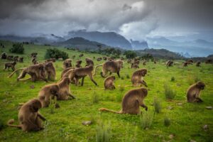
Massive erosion over the years on the Ethiopian plateau has created one of the most spectacular landscapes in the world, with jagged mountain peaks, deep valleys and sharp precipices dropping some 1,500 m. The park is home to some extremely rare animals such as the Gelada baboon, the Simien fox, and the Walia ibex, a goat found nowhere else in the world.
Outstanding Universal Value
Brief synthesis
Simien National Park, in northern Ethiopia is a spectacular landscape, where massive erosion over millions of years has created jagged mountain peaks, deep valleys and sharp precipices dropping some 1,500 m. The park is of global significance for biodiversity conservation because it is home to globally threatened species, including the iconic Walia ibex, a wild mountain goat found nowhere else in the world, the Gelada baboon and the Ethiopian wolf.
Criterion(vii):
The property’s spectacular landscape is part of the Simien mountain massif, which is located on the northern limit of the main Ethiopian plateau and includes the highest point in Ethiopia, Ras Dejen. The undulating plateau of the Simien mountains has over millions of years been eroded to form precipitous cliffs and deep gorges of exceptional natural beauty. Some cliffs reach 1,500 m in height and the northern cliff wall extends for some 35 km. The mountains are bounded by deep valleys to the north, east and south, and offer vast vistas over the rugged-canyon-like lowlands below. The spectacular scenery of the Simien mountains is considered to rival Colorado’s Grand Canyon.
Criterion(vii):
The property is of global significance for biodiversity conservation. It forms part of the Afroalpine Centre of Plant Diversity and the Eastern Afromontane biodiversity hotspot, and it is home to a number of globally threatened species. The cliff areas of the park are the main habitat of the Endangered Walia ibex (Capra walie), a wild mountain goat which is endemic to the Simien Mountains. Other flagship species include the Endangered Ethiopian wolf (or Simien fox, Canis simensis), considered to be the rarest canid species in the world and the Gelada baboon (Theropithecus gelada), both of which are endemic to the Ethiopian highlands and depend on Afroalpine grasslands and heathlands. Other large mammal species include the Anubis baboon, Hamadryas baboon, klipspringer, and golden jackal. The park is also an Important Bird Area that forms part of the larger Endemic Bird Area of the Central Ethiopian Highlands. In total, over 20 large mammal species and over 130 bird species occur in the park. The mountains are home to 5 small mammal species and 16 bird species endemic to Eritrea and/or Ethiopia as well as an important population of the rare lammergeyer, a spectacular vulture species. The park’s richness in species and habitats is a result of its great altitudinal, topographic and climatic diversity, which have shaped its Afromontane and Afroalpine ecosystems.
Integrity
The property was established in an area inhabited by humans and, at the time of inscription, 80%% of the park was under human use of one form or another. Threats to the integrity of the park include human settlement, cultivation and soil erosion, particularly around the village of Gich; frequent fires in the tree heather forest; and excessive numbers of domestic stock. Agricultural and pastoral activities, including both cultivation of a significant area of the property and grazing of a large population of animals in particular have severely affected the natural values of the property, including the critical habitats of the Walia ibex and Ethiopian wolf. The boundaries of the property include key areas essential for maintaining the scenic values of the property. However, they do not encompass all the areas necessary to maintain and enhance the populations of the Walia ibex and Ethiopian wolf, and a proposal to revise and extend the park boundaries was put forward in the original nomination. Whilst human settlements threaten the integrity of the originally inscribed property, two proposed extensions of the national park (the Masarerya and the Limalimo Wildlife Reserves, and also the Ras Dejen mountain and Silki-Kidis Yared sectors) and their interlinking corridors are free of human settlement and cultivation, and support the key species that are central parts of the Outstanding Universal Value of the property. Several assessments have considered that an extension of the property to match extended boundaries of the National Park, which to include areas with negligible human population are an essential requirement to maintain its Outstanding Universal Value.
Protection and management requirements
The national park was established in 1969 and is recognized and protected under national protected areas legislation. The property requires an effective management presence and the maintenance and increase of staff levels and training. Key tasks for the management of the park include the effective protection of the park’s flagship species and close cooperation with local communities in order to reduce the pressure on the park’s resources arising from agricultural expansion, livestock overstocking and overharvesting of natural resources. The pressures on the property are likely to increase further as a result of global climate change.
Significant financial support is needed for the management of the park, and the development of alternative livelihood options for local communities. The development, implementation, review and monitoring of a management plan and the revision and extension of the park boundaries, with the full participation of local communities, is essential. Community partnership is particularly important to both reduce community dependence on unsustainable use of the resources of the national park, and also to develop sustainable livelihoods. Adequate finance to support resettlement of populations living in the property, on a fully voluntary basis, and to introduce effective management of grazing is also essential to reduce the extreme pressure on wildlife. Improving and increasing ecotourism facilities, without impairing the park’s natural and scenic values, has great potential to create additional revenue for the property. Environmental education and training programs are also needed to support communities in and around the property as well as to maintain community support and partnership in the management of the property in order to ensure it remains of Outstanding Universal Value.
Simien Mountains National Park is one of the national parks of Ethiopia. Located in the Semien (North) Gondar Zone of the Amhara Region, its territory covers the Simien Mountains and includes Ras Dashan, the highest point in Ethiopia. It is home to a number of endangered species, including the Ethiopian wolf and the walia ibex, a wild goat found nowhere else in the world. The gelada baboon and the caracal, a cat, also occur within the Simien Mountains. More than 50 species of birds inhabit the park, including the impressive bearded vulture, or lammergeier, with its 10-foot (3m) wingspan.
The park is crossed by an unpaved road which runs from Debarq, where the administrative headquarters of the park is located, east through a number of villages to the Buahit Pass (4,200 m), where the road turns south to end at Mekane Berhan, 10 kilometers beyond the park boundary.

